The itinerary does require 4×4 driving skills, and this is the reason why we are only inviting those adventurous travelers we are sure will have no problems driving the famous and demanding Van Zyl’s Pass. We will get to the Pass, evaluate the situation together as a team, and if conditions allow, and all participants will be confident in driving, we will drive through. The itinerary will then move into the Etosha National Park, a wildlife paradise, and conclude in Windhoek.
Adventures in Living. This is a proper 4×4 overland expedition!


What makes this park unique are the waterholes and the concentration of wildlife around them. Etosha park is any photographers dream. Plan your visit to Namibia and experience the great white area of Etosha.
Etosha Game Park was declared a National Park in 1907 and covering an area of 22,270 square km, it is home to 114 mammal species, 340 bird species, 110 reptile species, 16 amphibian species and, surprisingly, one species of fish. Etosha Park is one of the first places on any itinerary designed for a holiday in Namibia.
Etosha, meaning “Great White Place”, is dominated by a massive mineral pan. The pan is part of the Kalahari Basin, the floor of which was formed around 1000 million years ago. The Etosha Pan covers around 25% of the National Park. The pan was originally a lake fed by the Kunene River. However, the course of the river changed thousands of years ago and the lake dried up. The pan now is a large dusty depression of salt and dusty clay which fills only if the rains are heavy and even then only holds water for a short time. This temporary water in the Etosha Pan attracts thousands of wading birds including impressive flocks of flamingos. The perennial springs along the edges of the Etosha Pan draw large concentrations of wildlife and birds.
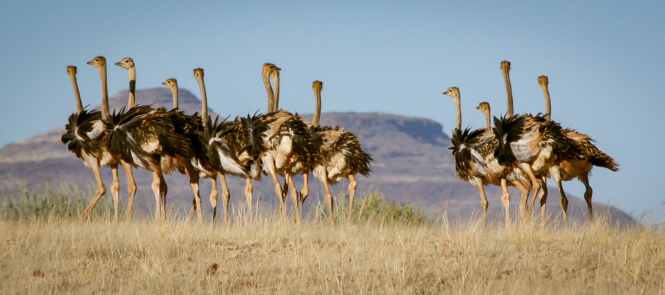
The game viewing in Etosha National Park is excellent, the best time being from May to September – the cooler months in Namibia. Visitors to Etosha Game Reserve can expect to see many buck species, elephant, giraffe, rhino, and lions. More fortunate visitors will see leopard and cheetah. There is a network of roads linking the five camps and subsidiary roads lead to various waterholes.
Kaokoland is an area in the NW corner of Namibia’s Kunene Region. It remains the most pristine and remote part of the country, much of it is still only accessible by 4×4 on hardcore tracks – not for the faint-hearted!
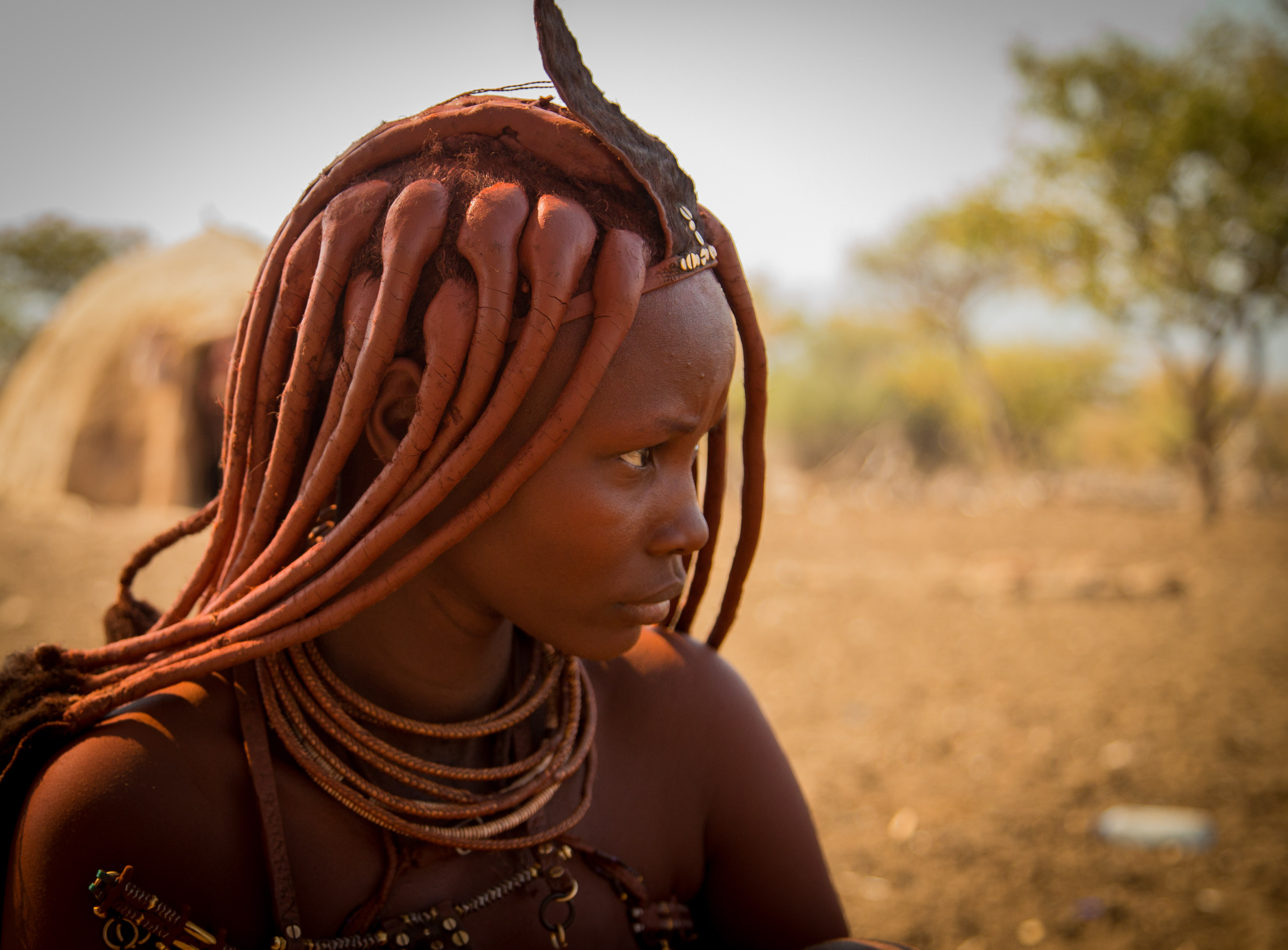
The local people in Kaokoland are mainly Herero and Himba. These two tribes are closely related, and both speak Otjiherero. However, Kaokoland is known for the Himba people, some of which still live a traditional lifestyle. Genuine OvaHimba people (those not assimilated by Western culture) can only be found in Kaokoland.
Overlanders know Kaokoland for the famous Van Zyl’s Pass, the most notorious pass in Namibia.
Located between two very steep mountain ranges in Namibia’s Marienfluss, it gets its name from the Dutch explorer who found the way across with a few hundred Himba and a Model T Ford in the 1920s.
It’s one of the highest roads in the country. Van Zyl’s Pass, at an elevation of 3,110ft (948m) above the sea level, is found in the far northwest of the country, in Kaokoland. It is a classic extreme road, even if not really a road, just a route made over the mountain by travelers over time. The outrageously steep pass itself is a pure adrenaline rush, but the lead-up trail is about 10 mi (10-15km) of tough driving, dodging its way through boulders, rocks, ravines, and badlands.
The descent from the top of the pass covers a distance of 6 miles – but it will take you three to six hours to negotiate.
Remoteness!
Damaraland was a name given to the north-central part of what later became Namibia, inhabited by the Damaras. It was bounded roughly by Ovamboland in the north, the Namib Desert in the west, the Kalahari Desert in the east, and Windhoek in the south.
During the Namibian summer (November-March) the Damaraland experiences very high temperatures of up to 40°C. The annual rainfall is low, some year it is completely absent. Numerous large dry river beds meander, which after heavy rainfall turn into torrential rivers within hours.
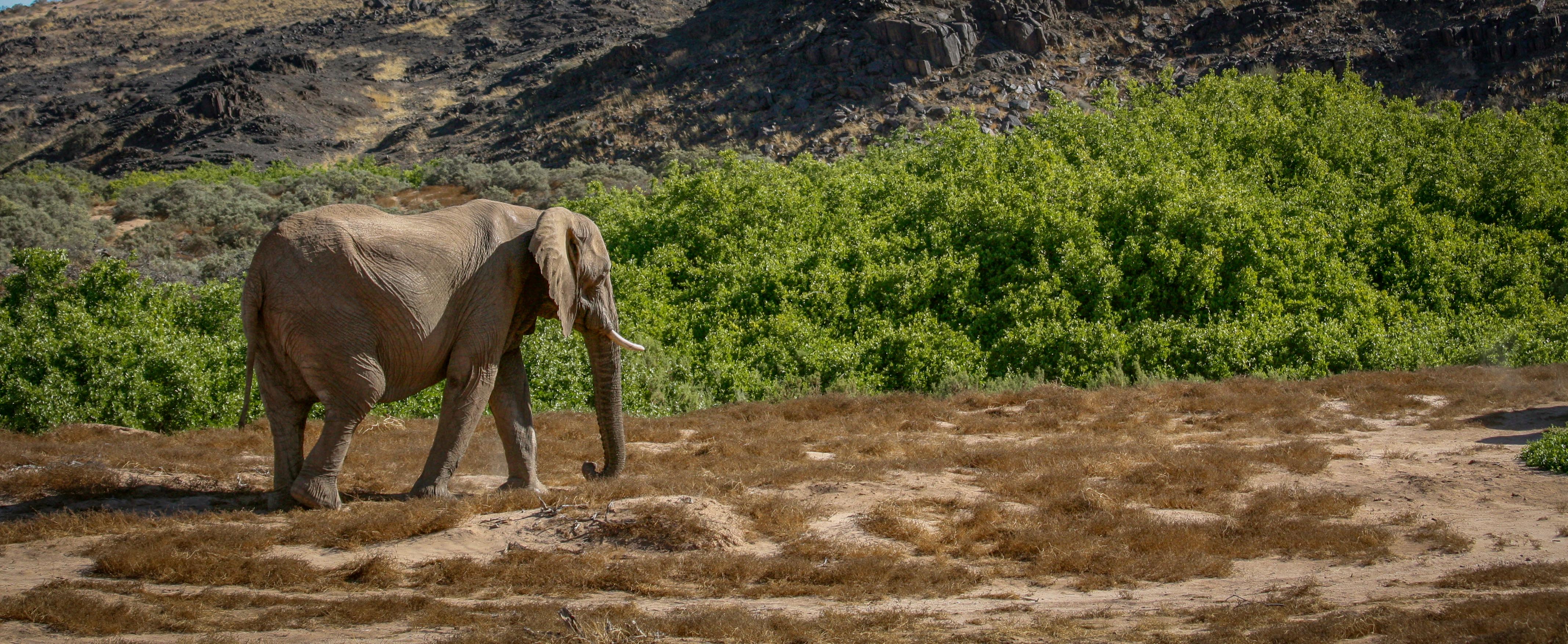
The flora and fauna of the region have adapted perfectly to the harsh weather conditions of high heat and persistent droughts. Here you find the desert-dwelling elephants who with elongated limbs and broader soles are able to handle the extreme rock and sand desert better and can travel for miles in the dry river beds in search of water. Also, the critically endangered desert lions managed to adapt to the arid climate. Numerous endemic desert plants are found in Damaraland such as the poisonous but photogenic Euphorbia Virosa and the ancient Welwitschia Mirabilis.
Scheduled departure from Windhoek
April-May, 2021
Dates, rates, and detailed itinerary upon request

These are among the most spectacular waterfalls in the world. The Zambezi River, which is more than 2 km wide at this point, plunges noisily down a series of basalt gorges and raises an iridescent mist that can be seen more than 20 km away.
Victoria Falls presents a spectacular sight of awe-inspiring beauty and grandeur on the Zambezi River, forming the border between Zambia and Zimbabwe. They are a UNESCO World Heritage Site.
Although the entire coastline of Namibia was formerly called The Skeleton Coast, more commonly today, it refers only to the Skeleton Coast National Park.
The Skeleton Coast is usually associated with famous shipwrecks, and stories abound of sailors walking for hundreds of miles through this barren Namibian landscape in search of food and water. The name came from the bones that lined the beaches from whaling operations and seal hunts, but more than a few of the skeletons were human. The Bushmen called it The Land God Made in Anger, and the Portuguese knew it as The Gates of Hell. Ever since European navigators first discovered it, ships have wrecked on its off-shore rocks, or run aground in the blinding fog. While small boats could land, the strong surf made it impossible to launch, hence the stories of sailors walking through the murderous terrain.
In the North, the park stretches from the Kunene River for about 300 mi (500 km) to the Ugab River in the South and protects about one-third of Namibia’s coastline. The Kunene River is one of Namibia’s few perennial rivers and forms one of the country’s two permanent estuaries.
The landscape includes sand dunes, canyons, and mountain ranges. The climatic conditions are not necessarily what you would expect in a desert country like Namibia – dense fog and cold sea breezes – and this is caused by the cold Benguela Current, which flows offshore, meeting with the extreme heat of the Namib Desert.
These two Namibia’s iconic landscape are in the Namib Naukluft National Park
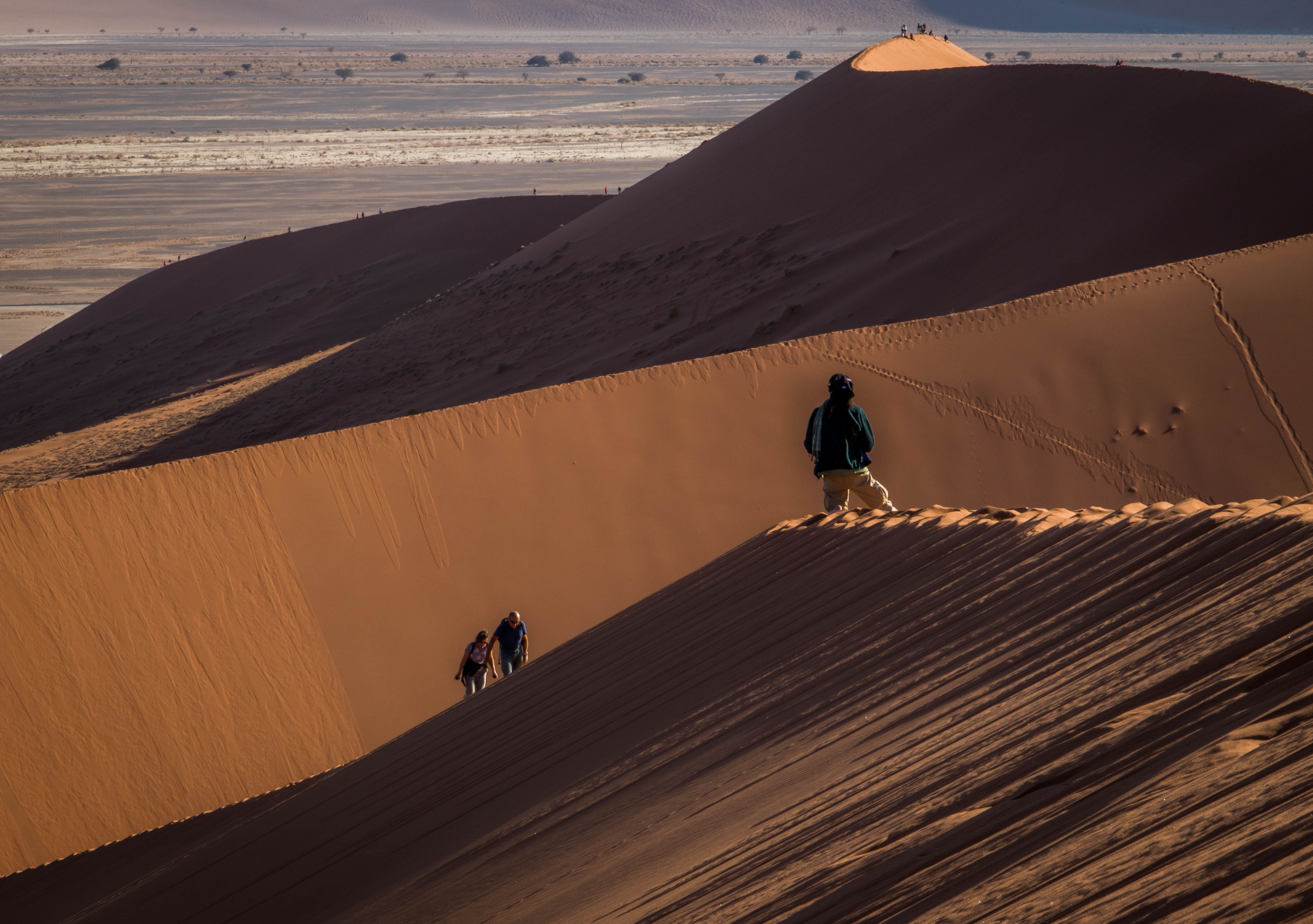
There is a reason why Dune 45 is on the cover page of most of the books on Namibia. It is indeed a star dune in the Sossusvlei area of the Namib Desert in Namibia. Standing over 560ft (170 m), it is composed of 5-million-year-old sand that is detritus accumulated by the Orange River from the Kalahari Desert and then blown here. A paradise for photographers. The best sunrise you will ever experience.
The major parts of the Namib Naukluft Park are inaccessible for humans. Of the huge area of which 12,500 sq mi (32,000 km²) exist of dune fields only the area north of the Kuiseb River, the Naukluft Mountains, and the Sossusvlei can be visited.
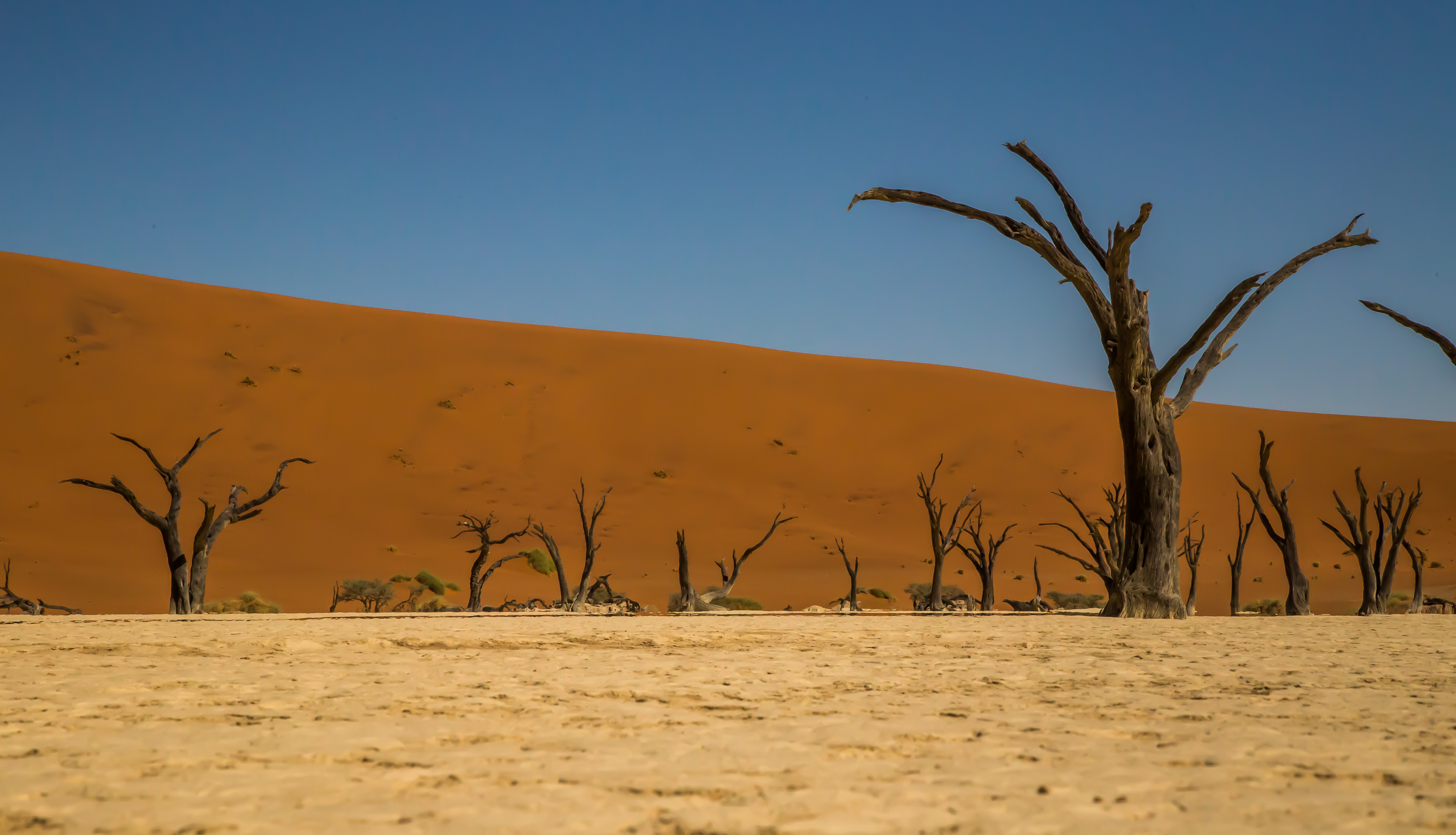
Close to Sossusvlei, Deadvlei is a clay pan characterized by dark, dead camel thorn trees contrasted against the white pan floor. The pan was formed when the Tsauchab River flooded and the abundance of water allowed camel thorn trees to grow. However, the climate changed and the sand dunes encroached on the pan, blocking the river from reaching the area. The trees are estimated to be approximately 900 years old, however, they have not decomposed due to the dry climate.
Deadvlei is a paradise for photographers as the contrast between the pitch-black trees and bleached-white pans, and the rusty-red dunes and deep blue sky make for incredible images.
One of Luderitz’ main attractions is Kolmanskop Ghost Town. This previously bustling diamond town is now abandoned and fights a constant struggle with the sand dunes of the Namib desert.
There are tours every morning around Kolmanskop which are very informative, a particular highlight of the tour is a visit to the bowling alley where you are invited to try your hand. After the guided tour you are welcome to explore the town at your leisure.
A paradise day for photographers.
World’s second biggest canyon!
The Fish River Canyon is the second largest canyon worldwide after the Grand Canyon in the USA. The Canyon forms part of the state-run Ais-Ais Richtersveld Transfrontier Park.
The Fish River is 800 km long and thus the longest river of Namibia. It has its source in the eastern parts of the Naukluft Mountains. After about 200 km the river flows into the Hardap Dam which is the largest water reservoir of the country with a circumference of 30 km and a surface area of 28 km².
After being retained the Fish River does not carry water continuously, only during the rainy season the river might turn into a torrent. During the dry season, sporadic pools supply water to many animals.
The Fish River Canyon commences at Seeheim, at the lower course of the River. The Canyon is 161 km long, 27 km wide and up to 550 m deep. The Fish River Canyon ends at Ai Ais and the river then flows into the Orange River, the border to South Africa.
It is important to know that during the summer month the Canyon hike is closed due to the heat. The Fish River Hiking Trail can be conducted during the months April – September and can be completed within 4 to 5 days, depending on fitness. It covers a length of 85 km and the descent into the Canyon is only allowed for hikers doing the trail. Day-visitors are not allowed to climb into the Canyon.
