What makes this park unique are the waterholes and the concentration of wildlife around them. Etosha park is any photographers dream. Plan your visit to Namibia and experience the great white area of Etosha.
Etosha Game Park was declared a National Park in 1907 and covering an area of 22,270 square km, it is home to 114 mammal species, 340 bird species, 110 reptile species, 16 amphibian species and, surprisingly, one species of fish. Etosha Park is one of the first places on any itinerary designed for a holiday in Namibia.
Etosha, meaning “Great White Place”, is dominated by a massive mineral pan. The pan is part of the Kalahari Basin, the floor of which was formed around 1000 million years ago. The Etosha Pan covers around 25% of the National Park. The pan was originally a lake fed by the Kunene River. However, the course of the river changed thousands of years ago and the lake dried up. The pan now is a large dusty depression of salt and dusty clay which fills only if the rains are heavy and even then only holds water for a short time. This temporary water in the Etosha Pan attracts thousands of wading birds including impressive flocks of flamingos. The perennial springs along the edges of the Etosha Pan draw large concentrations of wildlife and birds.
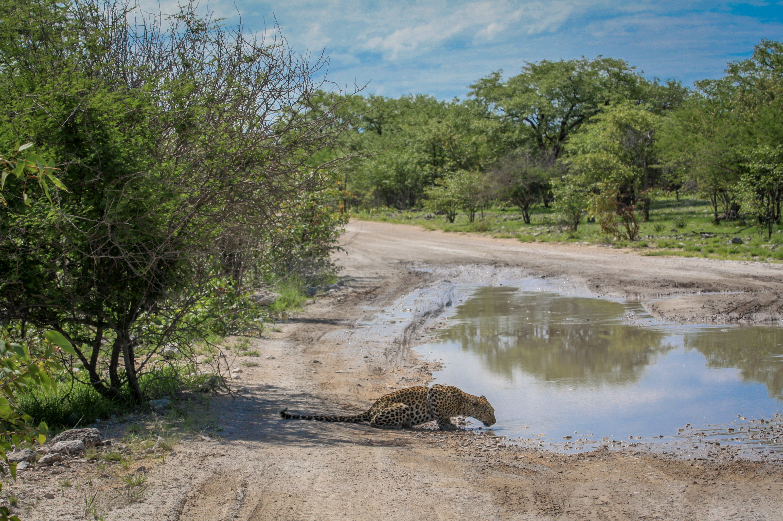
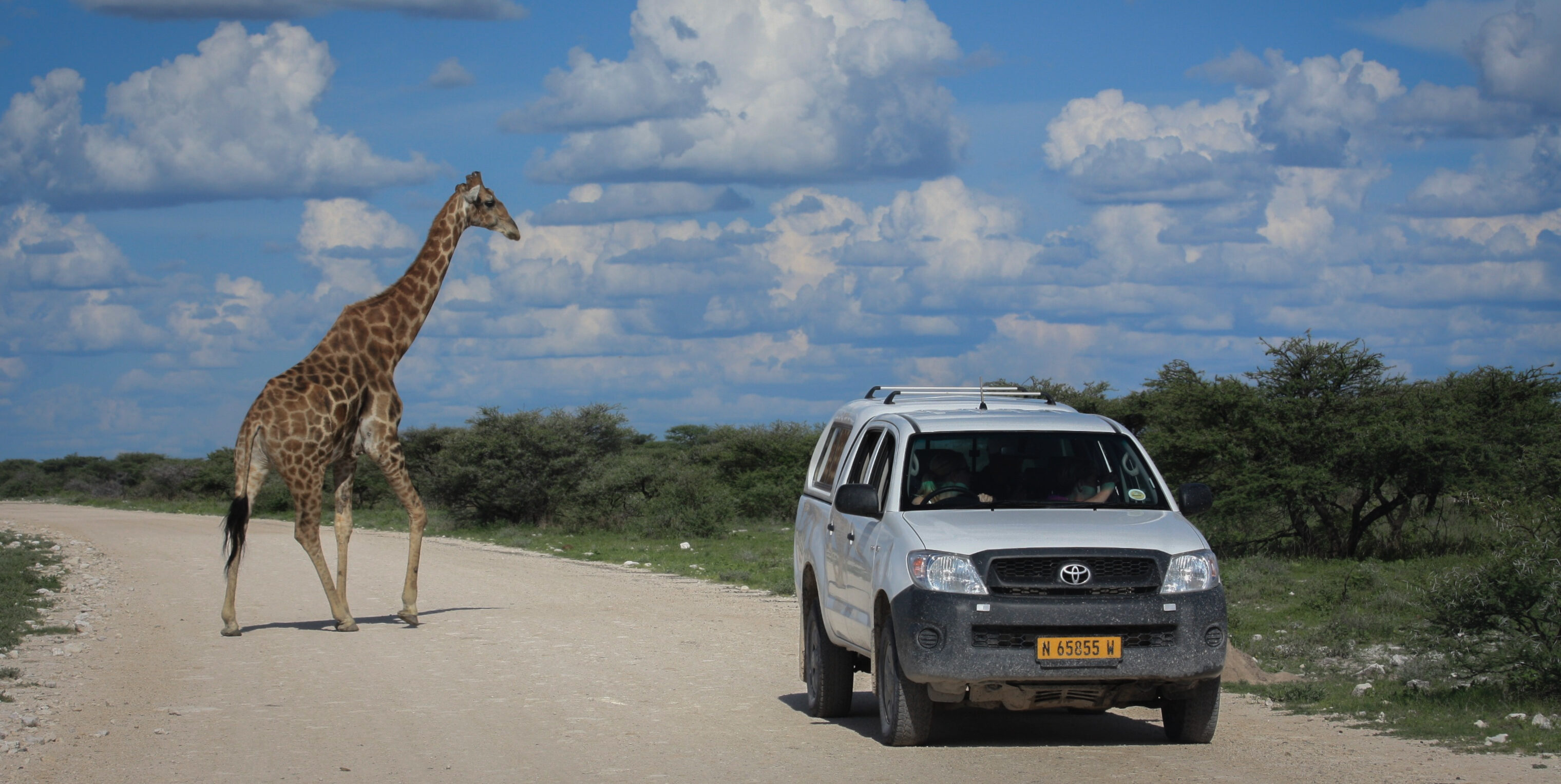
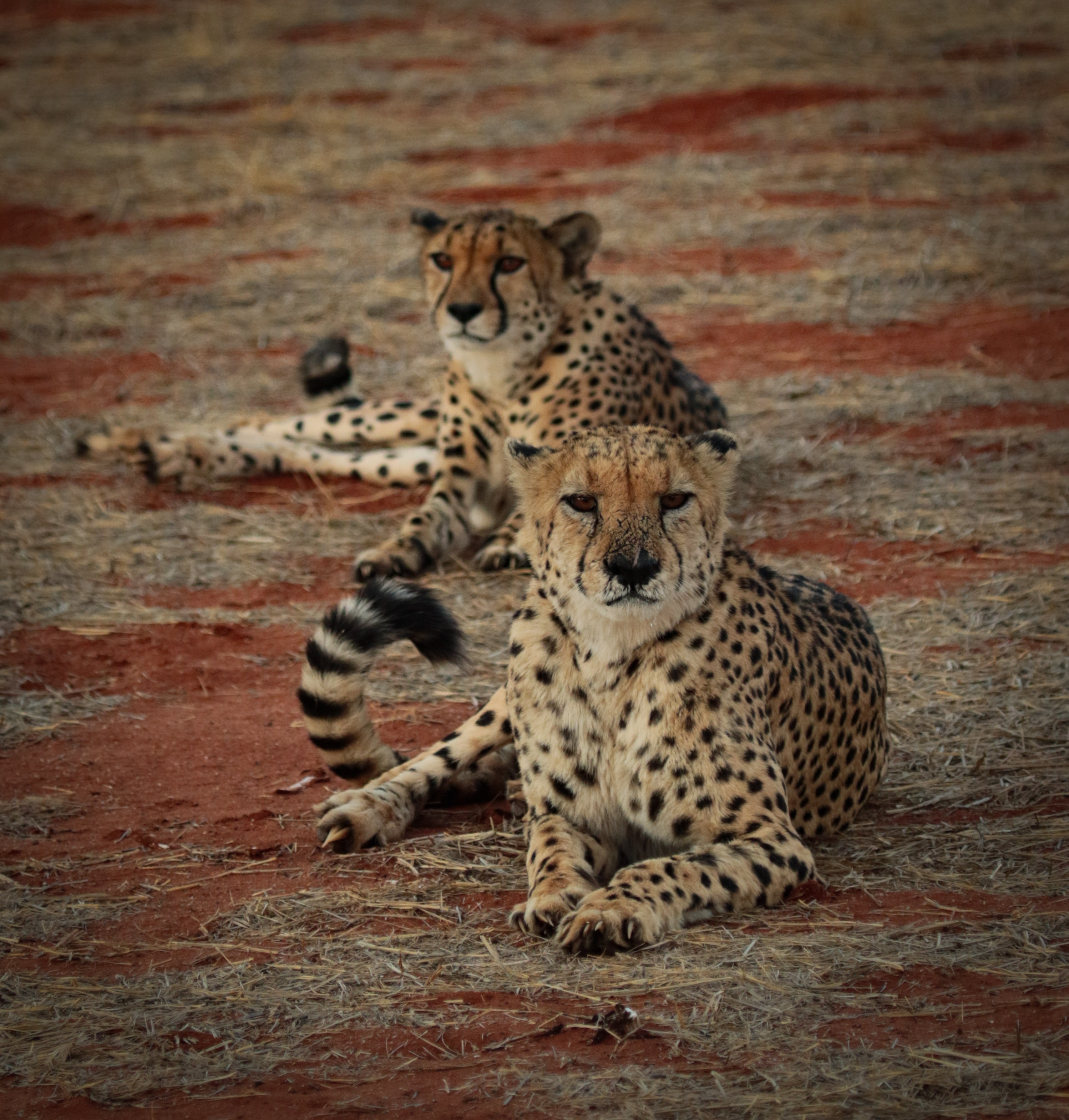
The game viewing in Etosha National Park is excellent, the best time being from May to September – the cooler months in Namibia. Visitors to Etosha Game Reserve can expect to see many buck species, elephant, giraffe, rhino, and lions. More fortunate visitors will see leopard and cheetah. There is a network of roads linking the five camps and subsidiary roads lead to various waterholes.
European traders and missionaries were the first recorded people who travelled through the area of Namibia that now contains Erindi, probably from Walvis Bay northwards in the direction of Ovamboland in the mid-1800s. But evidence shows that other people used to inhabit this land such as the indigenous Herero and San tribes. There are signs of seasonal Herero farmers having moved through the area, as well as significant San rock paintings and engravings on “Big Bushman” Mountain.
In 1986, the Joubert brothers bought the land from the Imperial Cold Storage and Supply Company (ICS). They were determined to turn it into a model cattle farm, so they invested money, time, and energy into the project. By the early 1990s, the brothers realized that to increase overall profitability of the farm, they would need to gradually start stocking the farm with game.
Natural food resources was a major concern, so to avoid competition with the cattle, they introduced plains game. They fenced 3 000 hectares and put 55 giraffes on it in 1992. This was a noticeably successful venture, so more game such as the Blue Wildebeest and African Elephant were brought in from Etosha National Park. The farm was already home to wild animals like the Gemsbok, Kudu, Leopard, Cheetah, Honey-Badger, Baboon and many others.
However, to concentrate fully on conservation and turn Erindi into a five-star ecotourism destination, the owners realized that the land would have to be briefly utilized for hunting purposes. A four-year period as a trophy hunting outfitter helped to raise the much-needed funds to continue their conservation dreams. Cattle farming had been completely phased out, and the reserve had been fitted with all the game management requirements. By 2008, Old Traders Lodge was erected and open for visitors. Since then, Camp Elephant was constructed, and several successful conservation programs run concurrently.
Courtesy from: Erindi Private Game Reserve
Remoteness!
Damaraland was a name given to the north-central part of what later became Namibia, inhabited by the Damaras. It was bounded roughly by Ovamboland in the north, the Namib Desert in the west, the Kalahari Desert in the east, and Windhoek in the south.
During the Namibian summer (November-March) the Damaraland experiences very high temperatures of up to 40°C. The annual rainfall is low, some year it is completely absent. Numerous large dry river beds meander, which after heavy rainfall turn into torrential rivers within hours.
The flora and fauna of the region have adapted perfectly to the harsh weather conditions of high heat and persistent droughts. Here you find the desert-dwelling elephants who with elongated limbs and broader soles are able to handle the extreme rock and sand desert better and can travel for miles in the dry river beds in search of water. Also, the critically endangered desert lions managed to adapt to the arid climate. Numerous endemic desert plants are found in Damaraland such as the poisonous but photogenic Euphorbia Virosa and the ancient Welwitschia Mirabilis.
Although the entire coastline of Namibia was formerly called The Skeleton Coast, more commonly today it refers only to the Skeleton Coast National Park.
The Skeleton Coast is is normally associated with famous shipwrecks, and stories abound of sailors walking for hundreds of kilometres through this barren Namibian landscape in search of food and water. The name came from the bones that lined the beaches from whaling operations and seal hunts, but more than a few of the skeletons were human. The Bushmen called it The Land God Made in Anger and the Portuguese knew it as The Gates of Hell. Ever since European navigators first discovered it, ships have wrecked on it’s off-shore rocks, or run aground in the blinding fog. While small boats could land, the strong surf made it impossible to launch, hence the stories of sailors walking through the murderous terrain.
The park stretches from the Kunene River in the north for approximately 500km to the Ugab River in the south, and protects about one-third of Namibia’s coastline.
The Kunene River rises in the remote Angolan highlands and is one of Namibia’s few perennial rivers and forms one of the country’s two permanent estuaries.
The landscape includes sand dunes, canyons and mountain ranges all of which are synonymous with Namibia. The climatic conditions are not necessarily what you would expect in a desert country like Namibia – dense fog and cold sea breezes – and this is caused by the cold Benguela Current which flows offshore, meeting with the extreme heat of the Namib Desert.
It looks like being in Germany!
Swakopmund, known as Swakop in Namibia, is the country’s biggest coastal town and a resort for Namibians on holiday. The city’s German origins are quite pronounced in beautiful old German colonial buildings throughout the city, making an even starker contrast for this town sitting at the edge of the Namib Desert.
Why we would like our clients to stay in Swakopmund? Beautiful dunes, a vibrant city, and above all, Sandwich Harbour.
Once you will obtain the permit (instructins will be given), you drive along a beautiful dune chain adjacent to the Atlantic Ocean, zigzagging the original railway line between Swakopmund and Walvis Bay. This is an opportunity for a detailed look at the formation of ‘the world’s oldest desert’, and the bird paradise surrounding you.
As soon as you get close to the dunes and the ocean, the dramatic landscape will capture your imagination. It will soon becomes clear why Sandwich Harbour is often described as inaccessible! Spring tides and shifting sands ensure an unpredictable route, but as you approach the towering, wind-sculptured dunes at the edge of Sandwich Harbour, there is a sense of entering a different world. You will drive on a thin stretch of sand between the dunes and the ocean.
A truly unique experience.
Dune 45!
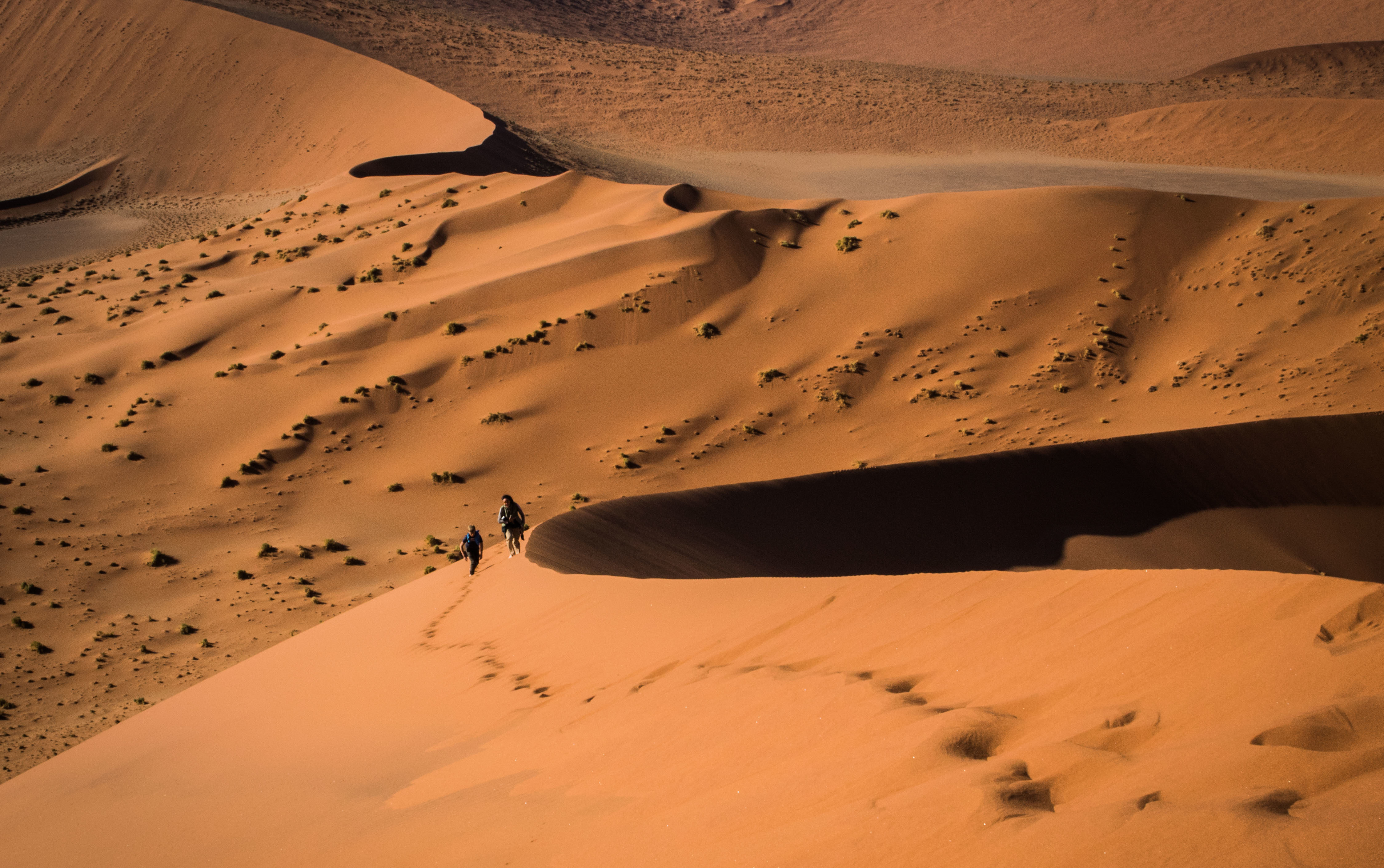
There is a reason why the dune is in the cover page of most of the books on Namibia. Dune 45 is a star dune in the Sossusvlei area of the Namib Desert in Namibia. Its name comes from the fact that it is at the 45th kilometre of the road that connects the Sesriem gate and Sossusvlei. Standing over 170 m, it is composed of 5-million-year-old sand that is detritus accumulated by the Orange River from the Kalahari Desert and then blown here. A paradise for photographers. The best sunrise you will ever experience.
The major parts of the Namib Naukluft Park are inaccessible for humans. Of the huge area of which 32,000 km² exist of dune fields only the area north of the Kuiseb River, the Naukluft Mountains and the Sossusvlei can be visited.
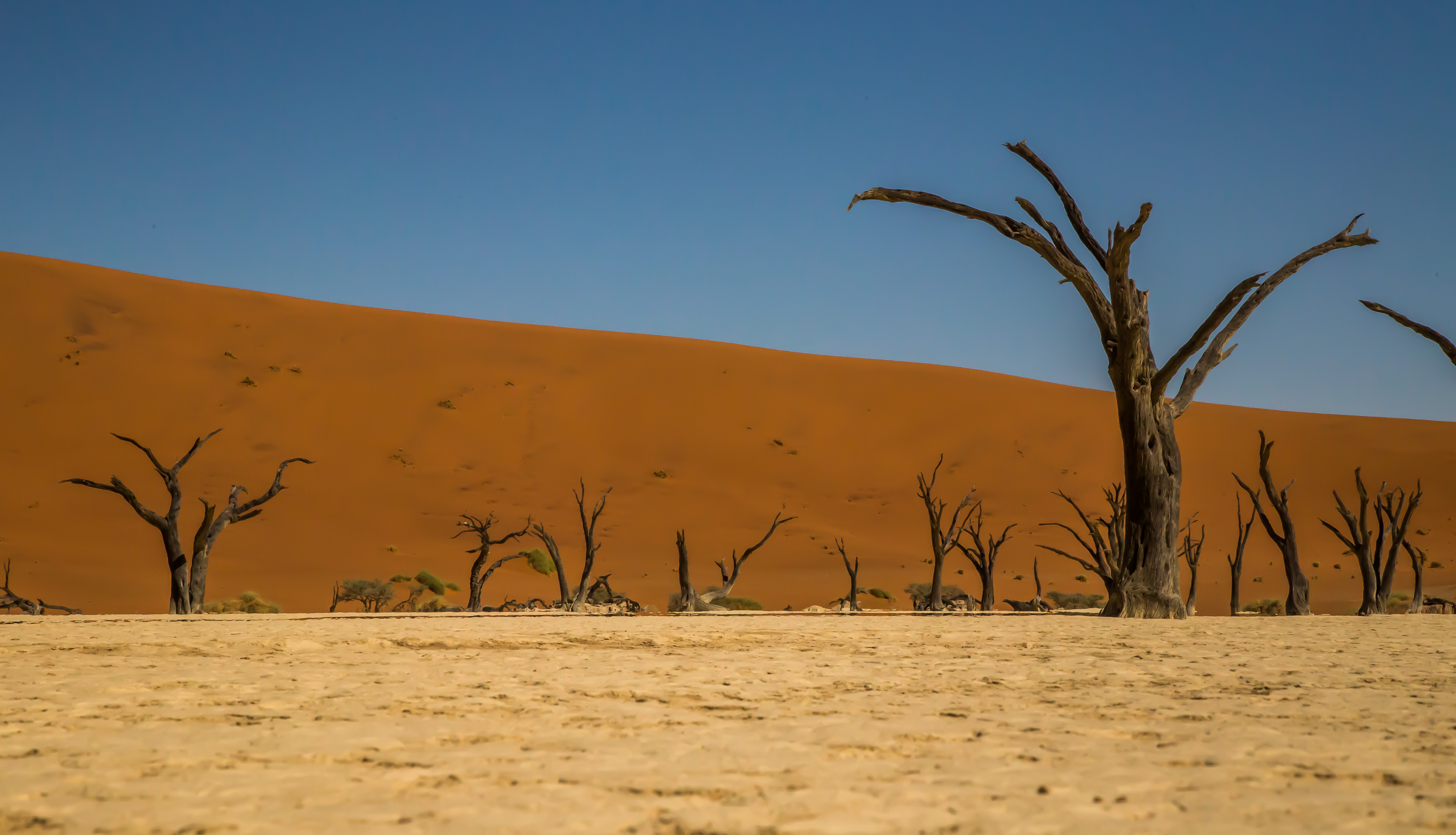
Close to Sossusvlei, Deadvlei is a clay pan characterized by dark, dead camel thorn trees contrasted against the white pan floor. The pan was formed when the Tsauchab River flooded and the abundance of water allowed camel thorn trees to grow. However, the climate changed and the sand dunes encroached on the pan, blocking the river from reaching the area. The trees are estimated to be approximately 900 years old, however they have not decomposed due to the dry climate.
Deadvlei is a paradise for photographers as the contrast between the pitch-black trees and bleached-white pans, and the rusty-red dunes and deep blue sky make for incredible images.
Day 1 – Arrive Windhoek – Hotel Olive Grove
One of our members will be waiting for you at the airport for your transfer to Olive Grove Guesthouse. Located close to the Windhoek city center, in a quiet and peaceful area, the Olive Grove Guesthouse is ideal to start and finish your journey through Namibia. This boutique guesthouse combines stylish architecture, simple but carefully selected decoration and personal service. Olive Grove Guesthouse caters for every need of the most discerning traveler, with emphasis on simplicity and elegance. Depending on your arrival time, you may meet with our representatives for the vehicle check and briefing on the itinerary, road conditions, food supplies, etc.
Service: Bed and Breakfast
Day 2 – Erindi Private Game Reserve
Erindi Private Game Reserve is a protected reserve in central Namibia. Erindi, meaning “place of water”, is a sustainable natural wonderland to pursue conservation initiatives in the name of eco-friendly tourism, whilst empowering our local communities. It contains over 10,000 animals and over 310 bird species. It comprises of 30 campsites and 15 self-catering chalets. Each campsite has its own bathroom with a toilet, solar-heated shower and hand basin. Campsites also have individual kitchens, with a washing up and food- preparation area. Each campsite has its own vehicle awning and a braai with an adjustable grid.
Service: Rooftop tent and self-catering
Driving time: 5h 30’
Day 3 – Namutoni Campsite – Etosha National Park
Today you will start your full immersion in the Etosha National Park. Namutoni is the first campsite you will stay. The Camp is situated in the eastern part of Etosha National Park and is accessible via the Von Lindequist Gate. Its close proximity to Fisher’s Pan makes Namutoni a hotspot for birders. The campsite area is very close to the lodge, and you will have access to food supplies and all the amenities of the structure.
Service: Rooftop tent and self-catering
Driving time: full-day safari
Day 4 – Halali – Etosha National Park (or Okaukuejo)
Halali Camp is strategically located halfway between Namutoni and Okaukuejo, where you will be exiting from the park. Halali is at the base of a dolomite hill, amongst shady Mopane trees. The Halali campsite is located next to the lodge and is easily accessible either through Anderson or Von Lindequist entrance gates. There is a floodlit waterhole. The elevated seating arrangements allow for excellent viewing of the watering hole at Halali. The waterhole provides exceptional wildlife viewing throughout the day and into the night.
Service: Rooftop tent and self-catering
Driving time: 1h 30’ + safari
Day 5 – Etosha Mountain Lodge – Etosha (Kaokoland)
Today you will leave the Etosha. On your way to Damaraland, you will stop at a beautiful lodge nestled in the exclusive Etosha Heights Private Reserve on the southwest border of Etosha National Park. You will relax in safari-chic chalets, all with 180 degrees, camera-loving panoramas of the wilderness, a beautiful main ‘lapa’ area, and a cool swimming pool for the hot Namibian days.
Service: Half Board plus picnic lunch
Driving time: 3h 30’
Day 6 & 7 – Ongongo Waterfall Campsite – Damaraland
Today you will travel to the area populated by the Herero tribe. Ongongo means “magical” in the Herero language. It is indeed a truly magical if not spectacular place. Set in a small canyon in the far northwest of Namibia, a completely barren landscape with some villages close by – you will find permanent water and a natural swimming pool with a waterfall.
From the campsite, it is relatively easy to organize a visit to an authentic Himba village, as well as exploring the Hoanib River, one of the most remote corners of Namibia.
Service: Rooftop tent and self-catering
Driving time: 5h 30’
Day 8 – Mowani Camp – Damaraland
Moving south, you will arrive at this fascinating camp, in the heat, dust and stunning landscapes of Damaraland. Rare, desert-dwelling elephants, springbok, gemsbok, and jackal roam these plains, while their images are found etched in the rocks at Twyfelfontein, Namibia’s first World Heritage Site.
Service: Full Board
Driving time: 3h
Day 9 – Spitzkoppe Campsite – Damaraland
This is the Eden for climbers, geologists, a rock hound, or a stargazer. One of the most beautiful corners of Namibia. The diverse and breathtaking landscapes will force your mind to think in vast stretches of time. The Spitzkoppe (“Matterhorn of Namibia”) is nearly 700 million years old.
Service: Rooftop tent and self-catering
Driving time: 4h 30’
Day 10 & 11 – Swakopmund – Desert Breeze Lodge
The time has come to drive to the coast. The road to Swakopmund is beautiful, and the scenery is ever changing. On your way to Swakopmund, we suggest a stop to visit the immense seal colony at Cape Cross and the famous Zeila shipwreck on the Southern border of the Skeleton Coast.
Why two days in a city? Swakopmund is a holiday destination, and you will find all types of activities including quad biking on sand dunes to scenic flights up the skeleton coast or you can drive on the sandy shoreline to Sandwich Harbour. The city has many supermarkets and restaurants, and it is the right place to find food supplies and any other necessities. The lodge is stunning. Its spectacular location provides peace and tranquillity away from the bustling town, and the privilege of savoring the ancient Namib Desert.
Service: Bed and Breakfast
Driving time: 3h
Day 12 – Kulala Desert Lodge – Sossusvlei
This is probably the longest stretch, and the drive will be very long. The destination is well worth the effort. Sossusvlei is definitely one of the highlights of your holiday. Kulala Desert Lodge is situated at the foot of the majestic Sossusvlei Dunes and is the closest lodge to Sossusvlei. This will allow you to get to the dunes before the sunrise. Depending on your wishes, you may go for an extraordinary desert experience with a soaring hot air balloon flight over the dune field.
Service: Full Board
Driving time: 7 hours
Day 13 – Namibgrens Guest Farm, South of Rehoboth
Please do your best to start as early as possible to enjoy the sunrise at Sossusvlei and Deadvlei. Then, head to Namibgrens Guest farm. Namibgrens holds many unspoken promises for nature lovers, soul seekers, and other extraordinary people. It is set in the perfect location; far enough from the hustle of busy towns but close enough for travelers seeking accommodation en route to Windhoek. The whispers of the desert will stay with you on your last night of this itinerary in Namibia.
Service: Full Board
Driving time: 6 hours
Day 14 – Depart Windhoek
As close as you can get to the Okavango Delta ecosystem, but with no tourists!
This lush tropical strip of land is both fringed and crossed by wide rivers, including the Zambezi, Kavango (Okavango), Chobe and Linyanti and it’s the natural corridor between the Etosha NP and Victoria Falls.
In the rainy season, the Popa Falls are spectacular, and the Nkasa Rupara National Park, between the Kwando and the Linyanti Rivers, shares the same water ecosystem of the Linyanti part of the Chobe NP (Botswana).
With so much water, the area supports a greater number of people than almost anywhere else in Namibia, and this, in turn, gives the Caprivi a very different feel to the rest of the country; in many ways more like parts of Zambia or Botswana.
The Caprivi makes a fantastic addition to any Namibia safari but perhaps is best suited to those on a return trip or a longer safari.
Added to this is the opportunity to get out on a boat, an enjoyable and often welcome contrast to sitting in a 4WD.
An expedition in a very remote area, only possible with at least two vehicles, and demonstrated overland experience.
Kaokoland is one of the last remaining wilderness areas in Southern Africa. It is a world of incredible mountain scenery, a refuge for the rare desert dwelling elephant, black rhino and giraffe and the home of the Himba people. Although it is harsh and offers little respite at midday, the rugged landscape is especially attractive during the early morning and late afternoon when it is transformed into softly glowing pastel shades.
The Marienfluss valley is very scenic and relatively greener than the Hartmann’s valley. Hartmann’s valley is closer to the Atlantic and yet much more arid. However, it does have a strange atmosphere when the sea mists drift inland.
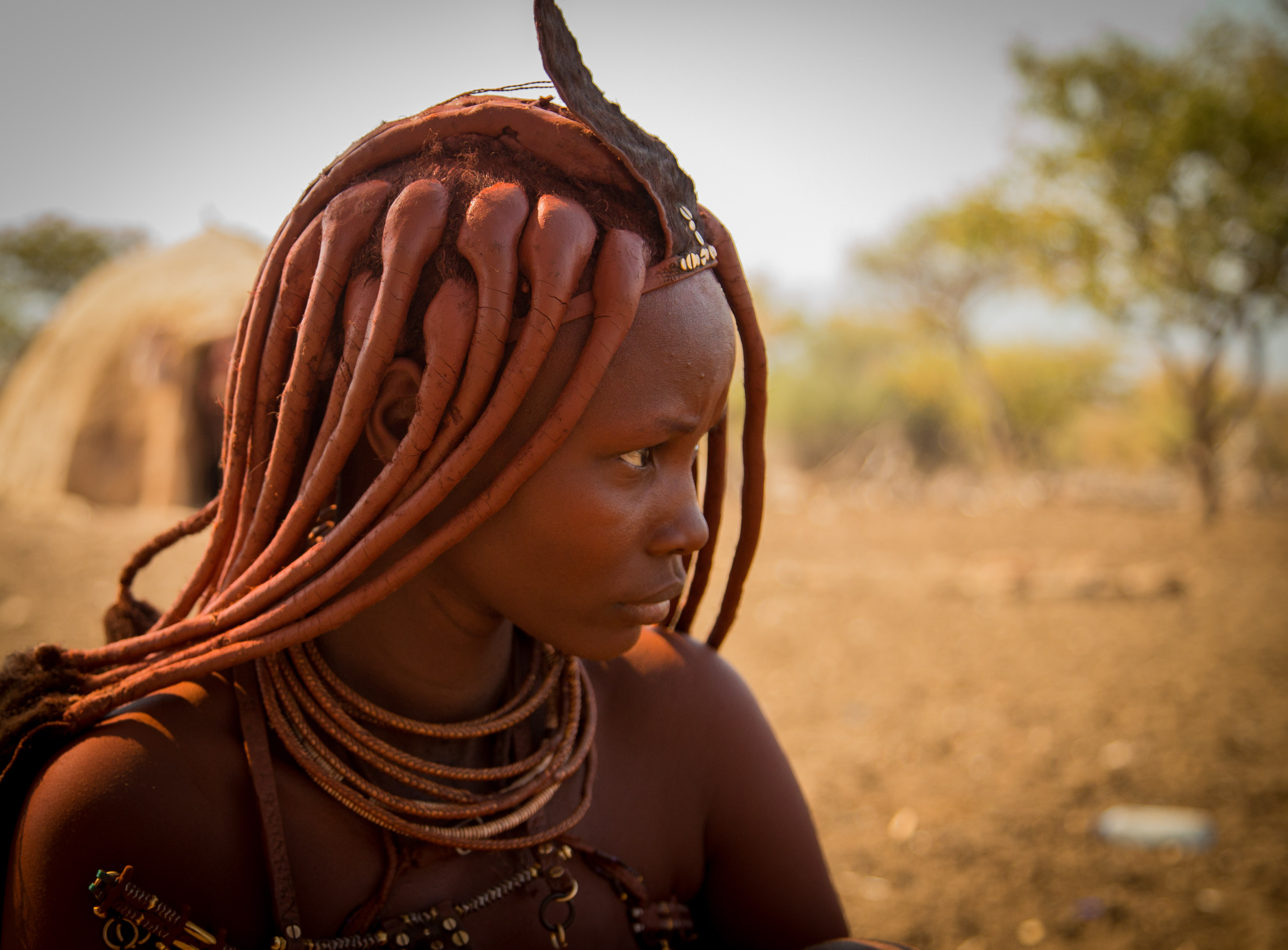
The Himba people who inhabit Kaokoland are the descendants of the earliest Herero’s who migrated into this area in the 16th century. Around the middle of the 18th century the pressure of too many people and cattle in this dry, fragile environment led to the migration of the main body of the Herero to the rich pasture lands further south. The Himba are an ancient tribe of semi nomadic pastoralists, many of whom still live and dress according to ancient traditions and live in scattered settlements throughout Kaokoland. They are a slender and statuesque people. The women especially are noted for their unusual sculptural beauty, enhanced by intricate hairstyles and traditional adornments. They rub their bodies with red ochre and fat, a treatment which protects their skins against the harsh desert climate. The homes of the Himba are simple cone-shaped structures of saplings bound together with palm leaves and plastered with mud and dung.
One of Luderitz’ main attractions is Kolmanskop Ghost Town. This previously bustling diamond town is now abandoned and fights a constant struggle with the sand dunes of the Namib desert. There are tours every morning around Kolmanskop which are very informative, a particular highlight of the tour is a visit to the bowling alley where you are invited to try your hand. After the guided tour you are welcome to explore the town at your leisure.
A paradise day for photographers.
World’s second biggest canyon!
The Fish River Canyon is the second largest canyon worldwide after the Grand Canyon in the USA. The Canyon forms part of the state-run Ais-Ais Richtersveld Transfrontier Park.
The Fish River is 800 km long and thus the longest river of Namibia. It has its source in the eastern parts of the Naukluft Mountains. After about 200 km the river flows into the Hardap Dam which is the largest water reservoir of the country with a circumference of 30 km and a surface area of 28 km².
After being retained the Fish River does not carry water continuously, only during the rainy season the river might turn into a torrent. During the dry season, sporadic pools supply water to many animals.
The Fish River Canyon commences at Seeheim, at the lower course of the River. The Canyon is 161 km long, 27 km wide and up to 550 m deep. The Fish River Canyon ends at Ai Ais and the river then flows into the Orange River, the border to South Africa.
It is important to know that during the summer month the Canyon hike is closed due to the heat. The Fish River Hiking Trail can be conducted during the months April – September and can be completed within 4 to 5 days, depending on fitness. It covers a length of 85 km and the descent into the Canyon is only allowed for hikers doing the trail. Day-visitors are not allowed to climb into the Canyon.